
IMD issues red alert as torrential rain lashes Mumbai; over 250 mm recorded in 24 hrs
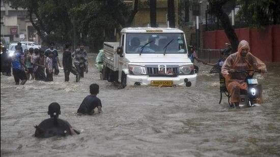
IMD Issues Red Alert for Mumbai Amid Torrential Rain
Bharatmorningnews.com – As torrential rain lashed Mumbai, the India Meteorological Department (IMD) issued a red alert, signaling the highest level of caution for the city and its suburbs. The extreme downpours, which exceeded 250 mm in a single day, have caused significant disruption, with waterlogging, traffic chaos, and potential damage to infrastructure. This unprecedented rainfall event has raised alarms across the region, prompting authorities to issue urgent advisories to the public.
Record-Breaking Rainfall and Regional Impacts
The rainfall surge in Mumbai has been particularly severe, with certain areas recording over 250 mm in the past 24 hours. IMD data reveals that the city’s island area saw 194 mm of rain, while the eastern suburbs recorded 217 mm and the western suburbs 186 mm between 8 am Saturday and 8 am Sunday. However, neighborhoods like Colaba and Santacruz experienced even higher levels, with Colaba reaching 265.6 mm and Santacruz logging 227.7 mm. These figures highlight the uneven distribution of rainfall, amplifying localized risks such as flooding and disrupted public transport.
Experts warn that such high precipitation rates are not typical for this time of year. While Mumbai has historically faced heavy monsoon rains, the current intensity and duration are classified as extreme. The situation has been compounded by a high tide of 4.19 meters predicted for Sunday afternoon, which could further elevate water levels in already saturated areas. This combination of heavy rainfall and tidal activity has led to concerns about prolonged flooding and its impact on daily life.
Weather Forecast and Wind Conditions
IMD’s updated forecast indicates that the torrential rain is expected to persist, with moderate to intense downpours continuing across Mumbai and neighboring Raigad. The weather system is anticipated to bring strong gusts of wind ranging from 55-65 kmph, increasing the risk of falling objects, power outages, and additional challenges for commuters. The department has also warned of possible lightning strikes, urging residents to avoid unnecessary travel and take shelter during the storm.
Residents and businesses have been scrambling to prepare for the worst. In addition to staying indoors, many have taken to social media to share updates on the situation, highlighting flooded streets and delayed services. The IMD’s red alert has prompted the city’s civic bodies to deploy sandbags and repair drainage systems in critical zones. However, the scale of the disaster has left officials concerned about the ability of the infrastructure to cope with the sudden influx of water.
Historical Context and Climate Trends
This extreme weather event marks one of the most severe monsoon episodes in Mumbai’s recent history. While the city has experienced heavy rainfall in the past, the current record-breaking levels suggest a shift in climate patterns. According to meteorological records, Mumbai typically receives an average of 250 mm of rain over a 24-hour period during the peak monsoon season, but this week’s figures have surpassed even the highest historical benchmarks. Such an anomaly may be linked to the increasing frequency of extreme weather events due to climate change, a trend observed globally in recent years.
Residents have also pointed to the economic and social consequences of the storm. With the city’s financial hub and commercial zones severely affected, businesses have reported losses due to halted operations and damaged property. The transport sector, particularly the suburban railway network, has faced significant delays, straining the city’s already congested infrastructure. Meanwhile, schools and offices have been forced to close, adding to the disruption caused by the weather.
Authorities have urged residents to remain indoors unless absolutely necessary, avoid flooded areas, and keep updated on weather advisories. The IMD’s red alert and the torrential rain have created a critical window for the city to assess its resilience against such extreme conditions. With the next high tide expected at 3.51 meters on Monday morning, the risks of prolonged flooding and waterlogging remain high.