
NYC flash flood map: Advisory and warnings issued as heavy rains to flood streets, highways, underpasses, basements
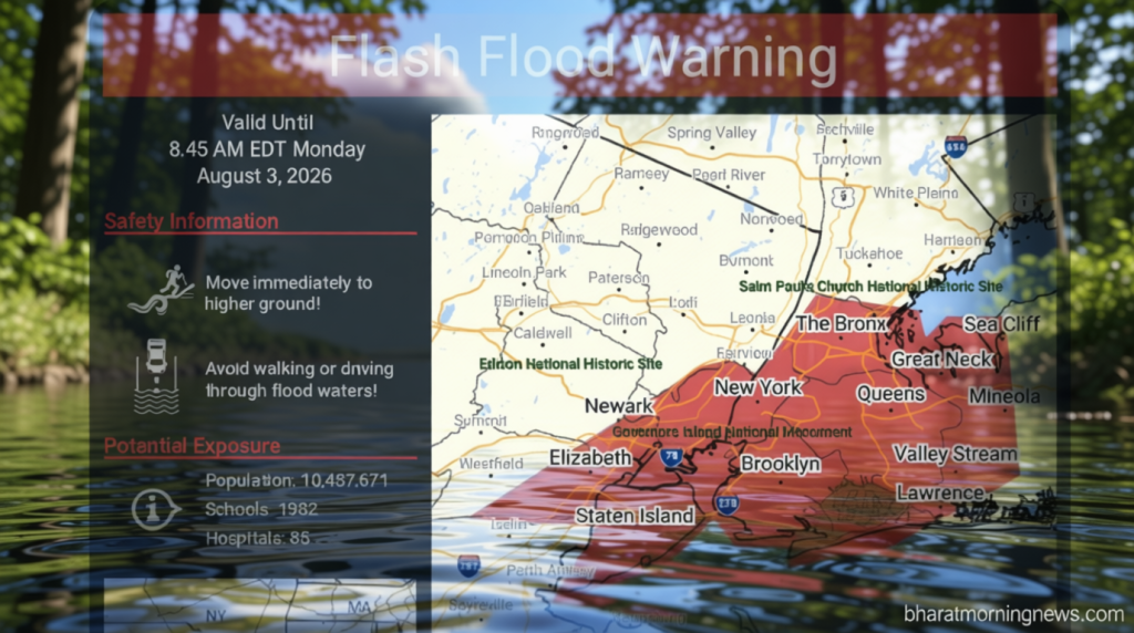
NYC Flash Flood Map: Warnings Issued for Heavy Rain Impact
Bharatmorningnews.com – The NYC flash flood map shows widespread alerts as New York City braces for significant rainfall this week. Residents across the five boroughs are being urged to prepare for substantial precipitation and potential flooding conditions. According to ABC7, the forecast predicts a wet and possibly stormy day spanning the Tri-State region, with concentrated rainfall and localized inundation as the main concerns for commuters and homeowners alike.
Weather experts are closely tracking where the most intense rain bands will develop throughout the metropolitan area. While many locations might receive only one to two inches of precipitation, pockets could see three to five inches if prolonged downpours persist overhead. Urban centers, especially New York City and areas situated along or just northwest of the I-95 highway, face the highest flooding risk if these heavier rain bands move directly across them.
Emergency Preparations Underway
The New York City Emergency Management Department has issued comprehensive alerts that intense rainfall may cause water to accumulate in streets, highways, underpasses, and basement levels across the city. In anticipation of the approaching weather system, municipal agencies have been busy clearing catch basins and removing debris from roadways to improve drainage capacity.
Emergency coordinators are advising New Yorkers to limit travel during harsh weather, avoid driving or walking through submerged roads, and take shelter inside during thunderstorms. Those living in basement apartments should consider moving to upper levels if flooding develops in their buildings.
Similarly, officials in New York City have cautioned motorists to watch for unexpectedly deep water on roadways and recommended that basement-dwelling residents relocate to higher floors as a precautionary measure.
Regional Impact and Timeline
A Flood Watch has been issued for much of New Jersey through Monday evening. The National Weather Service noted that while flash flooding remains the primary threat from any thunderstorms, isolated severe storms could also produce localized wind damage to trees and power lines.
Rain and storm activity is anticipated to decrease later in the afternoon and evening, though a lingering thunderstorm remains possible before drier air moves in overnight. The NYC flash flood map continues to be updated as conditions evolve throughout the day.
Early Monday morning in Paterson, New Jersey, several vehicles were observed stuck on a flooded roadway. Fortunately, all drivers managed to reach safety without incident, highlighting the importance of monitoring local conditions before traveling.
Residents residing in basement apartments are advised to relocate to higher floors should flooding occur. This precaution helps protect both property and personal safety during heavy rainfall events.
Frequently Asked Questions
What areas are most at risk for flash flooding in NYC?
Areas situated along or just northwest of the I-95 highway face the highest flooding risk. Low-lying neighborhoods, underpasses, and basement-level properties are particularly vulnerable to water accumulation during heavy rain events.
How long will the flood advisory remain in effect?
The Flood Watch has been issued for much of New Jersey through Monday evening. In New York City, conditions are expected to improve later in the afternoon and evening, though thunderstorms remain possible overnight.
What should basement residents do during a flash flood?
Basement residents should consider moving to upper levels if flooding develops. Emergency officials recommend relocating to higher floors as a precautionary measure to protect both property and personal safety.
Where can I find the latest NYC flash flood map updates?
The NYC flash flood map continues to be updated as conditions evolve throughout the day. Residents should check local news sources and the National Weather Service for real-time information on flooding conditions.
About the Author
Shweta Kukreti brings more than eight years of journalism experience covering Indian and international politics. Since joining Hindustan Times in 2024, she serves as Deputy Chief Content Producer, focusing primarily on the US desk. Her reporting spans US politics, immigration matters including H-1B visas, and major worldwide events.
Shweta places strong emphasis on collaborative newsroom operations, overseeing news monitoring, task delegation, editing, comprehensive coverage planning, and creating engaging, data-driven stories. Within her first year at the publication, she received the Digi Star Award for her extensive US politics coverage. In 2025, she achieved both a promotion and redesignation, recognizing her valuable contributions to the team.
Before joining Hindustan Times, Shweta worked with the Indian Express, HTDS, ANI, and Republic World, earning recognition from senior editors across all organizations. She holds a BA (Hons.) in Political Science and a master’s degree from Delhi University, along with a PG Diploma in English Journalism from the Indian Institution of Mass Communication. Additional credentials include a diploma in Women’s Empowerment and Development from IGNOU University and a French certification from Alliance Française de Delhi.
Outside of work, Shweta enjoys exploring hills and participating in adventurous activities in Rishikesh and Himachal Pradesh. She is an avid badminton, volleyball, and chess player who values time spent with friends and family, as well as spiritual practices.