
UN’s new map shows Arunachal, Aksai Chin as separate regions between India, China; MEA clarifies position
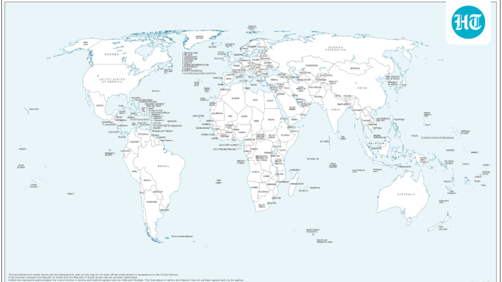
UN’s New Map Shows Arunachal, Aksai Chin Separately
Bharatmorningnews.com – UN’s new map shows Arunachal Pradesh and Aksai Chin as standalone regions wedged between India’s and China’s competing claim lines, prompting an immediate clarification from New Delhi’s foreign ministry. The cartographic choice, embedded in a revised world map released by the United Nations, has reignited debate over how disputed territories should appear on international cartographic products and whether a single projection can settle decades-old border questions.
What the Revised Depiction Contains
The updated map, first circulated on July 1 while General Assembly deliberations were still ongoing, strips Arunachal Pradesh of its shared boundary with Nagaland. In its place, the state appears as an isolated entity bordered by Assam to the west and China to the east. Aksai Chin — a high-altitude plateau claimed by India as part of Ladakh but administered by China — likewise receives its own separate designation. The UN has published no explanation for these particular cartographic choices.
In the Kashmir sector, a dotted line marks the Line of Control dividing Indian- and Pakistani-administered areas. A marginal annotation explains the convention:
“The dotted line represents approximately the Line of Control in Jammu and We Kashmir agreed upon by India and Pakistan. The final status of Jammu and Kashmir has not yet been agreed upon by the parties.”
New Delhi’s Diplomatic Clarification
At a Tuesday press briefing, MEA spokesperson Randhir Jaiswal stressed that India’s vote in favour of the underlying General Assembly resolution rested on the principle of equal-area cartographic projection, not on approval of any single map product. He noted that the resolution encourages projections preserving the true relative sizes of continents, countering the visual distortion of older formats such as the Mercator projection, which inflates landmasses nearer the poles.
“We favoured the resolution and voted in favour of the resolution. When the resolution was adopted in the UN General Assembly, we also made a statement where we clarified our position. The resolution is focused on the principle of equal-area maps. It does not endorse any map of any private party or any particular entity.”
Jaiswal added that the so-called Equal Earth map — the specific projection at the centre of the controversy — must not alter how existing national borders are rendered. India’s sovereign territory, including the Union Territories of Jammu and Kashmir and Ladakh, must appear in accordance with India’s official map, he stated, calling any inaccurate or misleading depiction “unacceptable” and India’s sovereignty position “clear, consistent and non-negotiable.”
Context: The “Correct the Map” Resolution
The African Union-backed measure titled “Correct the Map” was adopted by the UN General Assembly on September 4. Its stated aim is to encourage more accurate and equitable representation of the world’s regions, with particular attention to Africa, which has historically been under-represented in scale and detail on many widely circulated atlases. India’s earlier statement at the time of adoption signalled that its vote rested on the underlying principle of promoting equal-area cartographic representation, not on any endorsement of a named map product.
The two regions at the centre of this controversy have been flashpoints in Indo-Chinese relations for decades. Arunachal Pradesh, administered by India as a full state, is claimed by China as part of its “South Tibet.” Aksai Chin, linking India’s Ladakh with China’s Xinjiang, is administered by China but claimed by India as part of Ladakh. Both areas featured in the 1962 Sino-Indian War and remain subjects of periodic border standoffs. By depicting them as separate, undesignated zones, the UN’s new map shows how cartographic choices can amplify existing diplomatic tensions rather than resolve them.
FAQ
What does the UN’s new map show about Arunachal Pradesh and Aksai Chin? The revised depiction places both regions as standalone entities between India’s and China’s claim lines, removing Arunachal Pradesh’s shared border with Nagaland and giving Aksai Chin its own separate designation without a public rationale from the UN.
Did India endorse the specific map product? No. The MEA clarified that India’s vote supported the equal-area projection principle embedded in the General Assembly resolution, not any particular map produced by a private entity or organisation.
When